HSE Quarries Blasting and Explosives Seminar
4-7th March 1996
New Developments in Hole Deviation Measuring Equipment
J.G Whyte Altongate Ltd.
Hole Surveys in Relation to the Face Survey
The surveying of each hole is a separate exercise.
Each hole survey is an individual set of measurements relative to its own hole top.
How can we attach the hole surveys to the face survey ?
Each hole survey can only be attached to the face survey at a single point, the surveyed hole top.
The attachment point is effectively a pivotal point and only links the hole inclination data to the face survey, not the hole directional (azimuth) data.
What data do we need to do this correctly ?
The hole survey data should contain its own absolute azimuth information for each measured point (e.g. magnetic headings).
The face survey must be oriented to the same grid system.
We can then attach the hole surveys and be confident about the result.
Minimising Errors in Hole Surveys
We should avoid relative azimuth measurements.
Hole surveying systems which rely on orientating the hole survey device prior to commencing the survey and then make subsequent azimuth measurements relative to this initial setting are vulnerable to gross azimuth errors.
This is because any azimuth error in either the initial setup or the subsequent survey points are cumulative errors. The deeper the hole, the larger the potential error in determining the hole bottom position.
Systems which gather absolute azimuth information for each measured point do not suffer from this cumulative error effect and the azimuth accuracy improves as the number of measurements is increased.
2
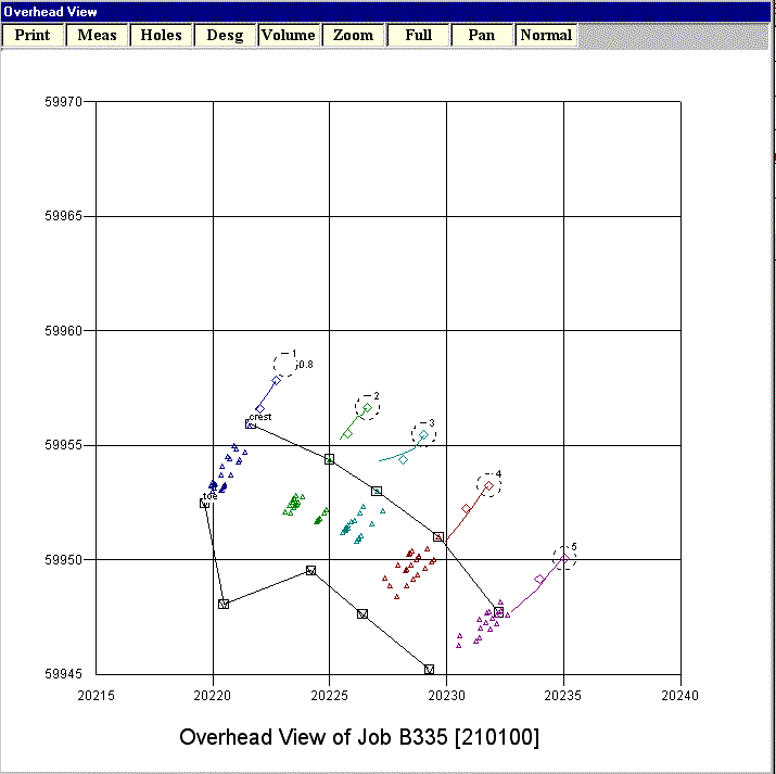
Figure 1 illustrates this effect. The profile data for holes 2 and 3 have had an azimuth error introduced at a point approximately 4m down the hole. Hole 3 simulates a rod system with a single worn or defective joint. Hole 2 simulates an electronic system with a "bad" measurement point (probe skewed in hole due to rock protrusion or cavity).
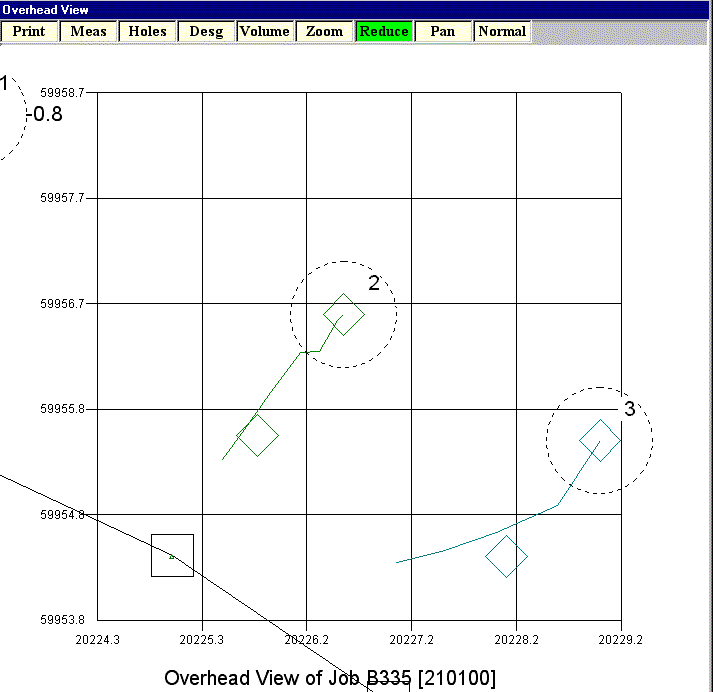
3
Figure 2 is an enlarged view of the same two holes. The azimuth error is the same in both cases but the effect on the survey is quite different. In the case of the electronic probe (Hole 2), the error is limited to a displacement D of the hole line by an amount equal to the depth measurement increment I multiplied by sine of the angular azimuth error ¶ µ i.e. D = I sin (¶ µ )
Setting up Errors
Any hole profiling system which requires the operator to align the equipment manually, can only produce data which are at best, as accurate as the accuracy of the setting up operation.
The accuracy of the measurements taken by such a system is wholly dependent on the competence of the operator.
Inclination accuracy considerations
Inclinometers are by their very nature, relatively simple devices. They are easy to calibrate and it is very easy to check the zero adjustment.
4
All hole profiling systems rely on the use of one or more inclinometers.
If we make the reasonable assumption that the data from each hole measurement point includes an absolute value of inclination, then inclination measurement errors are not cumulative.
The effect of inclination inaccuracy is identical to the effect of azimuth errors exhibited by the electronic hole profiling system.
In other words, inclination errors produce a displacement D of the hole line by an amount equal to the depth measurement increment I multiplied by sine of the angular inclination error ¶ µ i.e. D = I sin (¶ µ ).
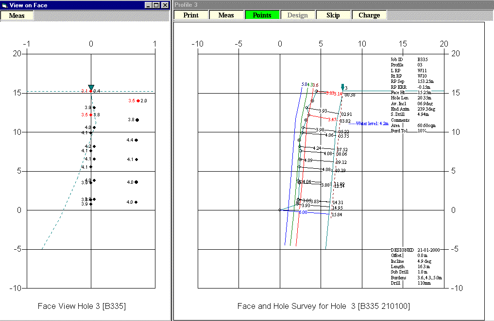
Figure 3 shows the effect of an inclination measurement error approximately 4m down an otherwise constant incline hole.
5
It is worth noting that this is the same hole 3 that appears in figure 1. The gross azimuth error is invisible on the profile view. The inclination error is equally absent from the overhead view.
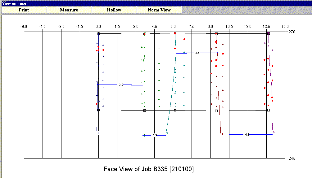
Figure 4 is a face (front view) of the same shot. The azimuth errors on holes 2 and 3 are visible, but they are not immediately obvious.
When and how to use Electronic Hole Profiling.
When ought we to use ‘down hole’ surveying ?
When the bottom of the hole can not be detected by lowering a torch. This means the hole is either bent, contains standing water or is both wet and bent.
Without employing some form of 'down hole' surveying tool, it is not possible to establish the complete path of the hole and it must surely constitute 'unsafe practice' to charge and fire that part of the hole whose path is unknown.
6
How do you use an electronic hole probe?
The cable winch is fitted to a standard surveying tripod.
The probe is connected to a suspension cable. This cable also contains electrical conductor wires via which the measurements made by the probe are transmitted to a portable data recorder on the surface.
The tripod is positioned over the hole to be surveyed in a way that when the probe is lowered into the hole it is lying against the back wall. This ensures that the best hole inclination results are obtained.
There are no alignment tasks to be performed.
The probe is lowered to the bottom of the hole and the depth is measured during the lowering operation using an electronic cable length measuring device.
The probe is then retrieved up the hole in stages, stopping at pre-determined depth intervals to record the azimuth and inclination. The depth increments need not be accurately spaced as the true depth will be automatically recorded for each survey point. The probe will inhibit its own transmission until it detects that the azimuth and inclination readings have stabilised.
The complete equipment may then be carried to the next hole and the procedure repeated.
How long does it take and how many people are needed?
It is a one man job. After setting up the equipment it only takes about 2 minutes to survey a 15m long hole.
What is the potential for operator error?
Virtually zero. There is no alignment procedure, no possibility of inaccurate depth positioning and stable measurements are automatically ensured.
The Design of an Electronic Hole Probe
What is an electronic hole probe ?
An electronic hole surveying probe is a self-contained sensor package which is designed to be lowered down a blast hole on a flexible suspension cable.
It is capable of determining the inclination from vertical and the magnetic azimuth normal to the plane on which it lies.
7
As it will suffer random rotation when lowered into the hole, it needs to be able to operate correctly irrespective of angular rotation about its longitudinal axis.
It is not a dynamic device and must be allowed to settle before a reading is taken. This is achieved automatically by inhibiting data transmission until at least two identical blocks of data (inclination and azimuth angles) are read by the microprocessor.
How does it measure inclination ?
It measures inclination by the use of two precision fluid level inclinometers mounted at right angles to each other.
A microprocessor within the probe mathematically (by vector resolution) combines the readings from the two inclinometers and calculates the absolute inclination of the probe irrespective of the angular rotation of the probe about its longitudinal axis.
A further calculation determines the angular rotation about its longitudinal axis in relation to a fixed diametric reference axis passing through the probe.
How does it measure azimuth ?
It measures azimuth by the use of a self compensating dual axis electronic magnetometer whose operation is managed by a separate microprocessor.
The magnetometer is mounted with its North axis aligned with the fixed diametric reference axis of the probe.
The outputs from the magnetometer are mathematically combined with the angular rotational information from the inclinometers to calculate the magnetic azimuth of a horizontal line normal to the plane on which the probe is lying
What else does it do?
It detects the level of water in the hole
It also monitors its own internal battery condition and validates each set of measurements accordingly.
How accurate is it?
The worst case non-linearity of the inclinometers over the range up to 30 degrees from vertical is 0.5%. This equates to an accuracy of better than 0.15 degrees.
8
The measuring resolution of the inclinometers is ± 0.01 degrees.
The magnetometer itself is self compensating and the worst case non-linearity is plus or minus 0.5 degrees.
Due to the nature of the solid geometry calculations, the accuracy of the azimuth value after case rotation correction degrades progressively as the measured incline approaches
vertical. In fact, the case rotation correction is switched off when the inclination becomes less than 2 degrees and the azimuth data is then random.
This does not create a serious problem because the maximum error under these circumstances is less than 3mm per metre of hole. In any case, the random rotation of the case will tend to average out any azimuth errors in near vertical holes. Azimuth accuracy is not important for near vertical holes. Remember, that a vertical hole has no azimuth attribute.
With a typical hole incline of 10 degrees the azimuth accuracy will be better than plus or minus 1 degree.
What repeatability can we expect from an electronic hole probe ?
Tests involving repeated surveying of the same 20m hole using 2m measuring intervals have shown that the measured offset position of the hole bottom with respect to the hole top will be within plus or minus 0.2m of the mean position.
What errors is an electronic probe subject to ?
The only possible error other than an outright malfunction is the presence of significant amounts of magnetic material in the rock being quarried. Such materials will cause azimuth errors.
This should not constitute a problem in the vast majority of quarries.
A simple tripod test with a quality magnetic compass mounted on a mechanical horizontal circle would be sufficient to determine whether a problem exists.
If significant amounts of magnetic material are present in the rock then the site could not be considered as suitable for the usage of a fully electronic blast hole probe.
9
Electronic Probe as diagnostic tool
If the bottom of the hole can not be detected by lowering a torch, then the position of the hole relative to the free face is unknown. In these case it is imperative to use an electronic probe and associated software to plot its position.
If errors have occurred in the correct position of the hole then the survey should be analysed for obvious indications of incorrect setting up of the drill rig equipment.
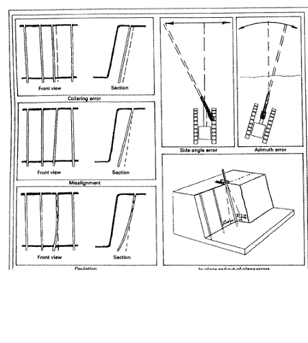
These could be caused by mechanical wear in the drilling equipment, alignment devices which are out of calibration or operator ignorance due to lack of training. These can cause hole collaring errors, misalignment and deviation errors. (Figure 5).
With acknowledgement to Accurate Blast-Hole Alignment by Bob Pemberton,Quarry Management May 1990
10
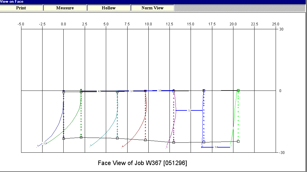
More significant errors can be caused by geological faults (Figure 6). This was part of a concave face approximately 100m wide. By monitoring the hole surveys with the electronic probe it showed that the drilling was always affected at this section of the face and was not caused by poor drill alignment. Figure 6 shows how holes 1 to 5 have been effected by a fault approximately 10m down from the top of the hole. The fault has all but disappeared by holes 6 and 7.
.
hsedocument QUARRYFILE